
Need a printed map which is bigger than your printer can handle or which works without power or batteries? Paper maps are getting harder to find. Here is what is available in Charlottesville.
Available Maps by Location
- Virginia Department of Mines, Minerals, and Energy. Fontaine Research park. 900 Natural Resources Drive, Charlottesville, VA. Has USGS topo maps including the 7.5minute quads and coarser sizes for the entire state of virginia. You order online and click the “Pick up at DMME Charlottesville, VA” checkbox or else they will add shipping charges and mail it (from Charlottesville). If you go there in person, they will sit you down at a computer so you can order the maps on the website. https://www.dmme.virginia.gov/commerce/
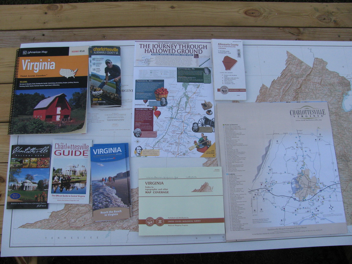
- USGS Albemarle County 1:50,000 scale Topo Map, Year 1991. $9 38078-A4-CF-050 ISBN 0-607-56701-5. UPC 9-780607-567014. Folding Map. Top half on front, Bottom half on back. Roughly 29″ high by 53″wide. USGS product 105009
- 1:100,000: Charlottesville. $9 Coverage: 30’x60′ (30minutes of latitude by 60 minutes of longitude), Size 41x24inches. Get the Dillwyn map below for bottom half.
- 1:100,000: Dilwyn
- USGS, Virginia Base Map with Highways, Contours and Shaded Relief (1:500,000) $9 Year: 1973. 60×30 inch paper map, not folded, not laminated. Very old but major topographic features and roads which are major enough to show on this map don’t change much.
- Virginia: Index to topographic and other Map Coverage. ISBN 0-607-84585-6. UPC 9-78-0607-845853. !-SS-35-20.000 9-93 . This map is useful for locating the appropriate Topo map quadrangle names whether you are using paper or electronic formats. I was able to get a copy of that map for free in person though it isn’t listed on the site..
You can also order it free from USGS: VA Index Map.
I haven’t found the exact map online yet. There are some maps which resemble excerpts:
Geomart’s pdf index map is similar, but only has the 7.5minute quadrangles.. omnimap tiff version is similar to geomart. Virginia tech version is broken into pieces. - 7.5Minute Quads. Curiously Charlottesville West and Charlottesville East are missing form the online list. Those that are listed are rather old. Abilene was photorevised in 1980 and Simeon in 1974. The online US Topo geoPDF maps are much newer (this year).
- Raised Relief Maps. They have Charlottesville (but Roanoke which is needed because charlottesville is near bottom edge isn’t listed), Virginia, US, and the World. Prices start around $28.50.
- Blue Ridge Mountain Sports. Has the more popular 7.5 minute quads for hikers in this area. Discounted by a penny ($7.99) and no shipping. The maps are actually there for you to look through and a portion of the index map is on the top of the map cabinet. They also have Appalachian trail maps and other hiking maps. They referred me to the Department of Mines for missing maps.
- USGS paper maps can also be obtained online from USGS and many are also available as free PDF downloads. Most other than 7.5minute quads are quite old.
- Barnes and Noble. Has the Virginia Atlas and Gazetteer (book map) as well as some neighboring states (Virginia was out of stock when I was there). Has laminated US and World maps for $20, $14 for one, $6 for one unlaminated.
- Charlottesville Visitors Center. Two locations: main one inside Downtown Transit Station on the downtown mall and one at the Albemarle County Office Building (north) on MacIntire Road. Has a free Charlottesville visitors map. This is considerably less detailed than the $0.50 VDOT map and focuses on tourism. Area covered is roughly similar to Albemarle county. Layout does not appear to be geographically accurate, not useful with a compass, directional antenna, etc. No grid lines, north is not up. Beware that they have an official visitors guide that is diguised to look like a folding map of Charlottesville/Albemarle; it not only isn’t, it doesn’t contain any maps. They have The Charlottesville Guide with some small maps at different zoom levels.
The also have the Charlottesville Welcome book/li> - Piedmont Crossroads Visitors Center. Near I-64 & 15 in Zion Crossroads. It is actually a side entrance to the hotel. .Very little in the way of maps other than the geographically inaccurate visitCharlotteville.org map and “the Journey through Hallowed Ground” (route 15 corridor from Charlottesville to Geettysburg, PA).
- VDOT. Order online. Regional office in Culpepper might have maps. The free 2012-2014 Official Virgina State Transportation Map is a decent map. But I checked the Charlottesville and Richmond rest areas and they did not have the map. VDOT has county maps for $0.50 each or a complete set for $35 (bound or unbound, your choice). Note that they may exclude major cities. You can download scanned versions for Albemarle and neighboring counties from the Cville Bike Club. VDOT also has city maps; these have very little detail and are just the insets from the state map. Free Hurricane Evacuation guide includes map of hurricane evacuation routes.
- University of Virginia Visitors Center. Ivy road next to the Emergency Communications Center (911 Call Center) and inside the UVA police station. Has Paper UVA maps.
- Exxon Station/Wendy’s on Pantops; intersection of 250 and 20(stoney point rd): American Map Virginia Highway Atlas $20. I got the last one in stock. Not topographic (unilke the atlas and gazetteer). Charlottesville is on the bottom edge of Map 13/Map14 and a half page more detailed Map 71 which still doesn’t show most residential streets.
- Target (earlysville): Virginia Atlas and Gazetter for $11.97 in stock.
- Walmart has the Virginia Atlas and Gazetteer available for site-to-store pickup (1 week delay).
- 2013 Virginia Wine Guide in state map format. Only major highways shown.
- ADC Virginia State Western Cities & Towns Street Atlas. $9 online. Product #: 1603727; ISBN: 0762575042; UPC: 02432775046227 Note that this is only a 5.25×8.5″ page size. Charlottesville is two pages which is equivalent to one sheet of letter size paper.
7.5minute quadrangles in the immediate area
Laid out geographically in 6×6 grid. Those which include parts of Albemarle County are marked with an asterisk.
| Grottoes | McGaheyesville* | Swift Run Gap* | Standardsville | Rochelle | Madison Mills |
| Crimora* | Browns Cove* | Free Union* | Earlysville* | Barborsville* | Gordonsville* |
| Waynesboro East* | Crozet* | Charlottesville West* | Charlottesville East* | Keswick* | Boswells Tavern* |
| Greenfield* | Covesville* | Alberene* | Simeon* | Boyd Tavern* | Zion Crossroads |
| Lovingston | Schuyler* | Esmont* | Scottsville* | Palmyra | Columbia |
| Shipman | Howardsville* | Glenmore* | Diana Mills | Arvonia | Lakeside Villiage |
SeeminglyExtinct
These are seemingly non-existent or really hard to come by for many areas that previously had them.
ISBN: 0762573988; UPC: 02432773981828 but I haven’t seen that around anywhere local. It is listed as 2011 but currently unavailable on Amazon.
ADC Albemarle County Street Atlas for example is no longer printed. Someone offered for sale for over $400 used on amazon, barnes and noble, etc. BTW, Universal Map Group has bought out ADC and American Map and Hammond World Atlas Corporation. Note that these types of atlases are still Available from ADC for Richmond, VA , Prince William County, VA., Facquiier County but not Fairfax County.
Map Handling
- Tackless paper hangers: 96″ $31,48″ $17, 36″ $14, 24″ $10, 12″ $6, 7″ $5. Google Products Search. Shipping about $5 for 96″ version according to google products. More than one brand and many sellers available. There is another brand (actually bought out by the same company) that seems much more expensive but they come in sets of 6. Mount these on a wall or above a whiteboard. To hang a map, just shove it up into track and pull down and let the cam rollers grab it. To release lift up. One track can hold multiple maps. Use for maps, charts, blueprints, etc. Good for ham shack, trailer (perhaps on outside as well as inside), emergency operations center, hallway, conference room, shop, etc.
- older Map rails
- Drafting Table, if you have room
- Map cabinets
- Telescoping Blueprint tube (aka art tube) or even a mailing tube to carry rollup maps.
- Waterproof see-through map cases
- Posterboard/presentation board and binder clips
- Binder clips screwed to wall with a fender washer can also be used to hang maps
- Measuring devices: transparent map scales and map protractors, map roller/wheel, digital calipers, etc.
- Clear cellophane overlays
- Contact paper or laminating rolls
- Make your own pull down maps with roller shades.
- 3m Command adhesiveâ„¢ poster hanging strips, or command adhesiveâ„¢ hanging hooks used with binder clips.
- Poster rails and hangers
- Poster frames
Electronic Maps have been written about in earlier stories
BTW, I now have electronic copies of all 824 US Topo 7.5minute quad maps for the state of Virginia. This includes maps of quads which are officially in neighbouring states where needed to get coverage of border areas. Total size is about 25.5GB.