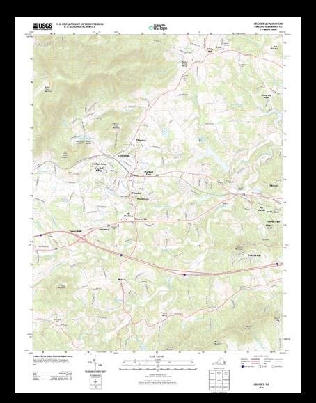
Crozet quadrangle
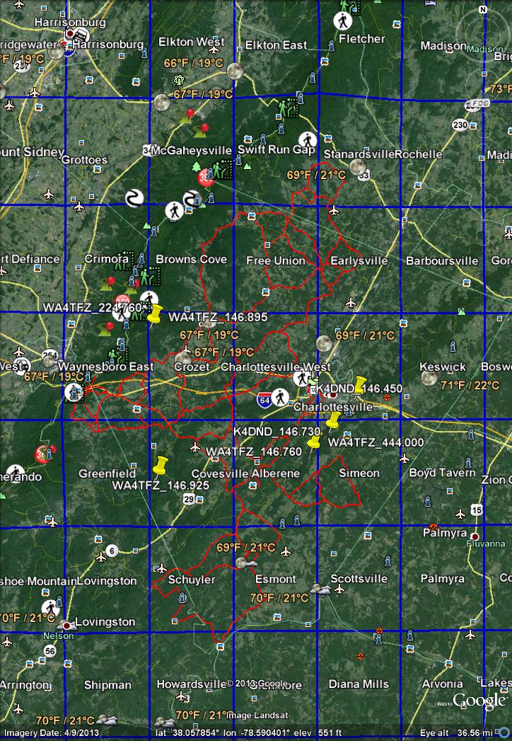
The following 7.5minute quadrangles cover the routes for the BGCCC, Gran Fondo Virginia, and Miller School Bike Race: Swift Run Gap, Stanardsville, Browns Cove, Free Union, Earlysville, Waynesboro East, Crozet, Greenfield, Covesville, Alberene, Schuyler, Esmont, and Howardsville. Charlottesville West, Charlottesville East, and Simeon would also be desirable as they cover the area immediately around Charlottesville, including some of our repeater locations.
Miller School Road Race 2013 only needed Crozet and Covesville.
BGCCC 2013 needs: Swift Run Gap, Stanardsville, Browns Cove, Free Union, Earlysville, Waynesbora East, Crozet, and Greenfield
Gran Fondo Virginia 2013 needs: Waynesboro East: Crozet, Greenfield, Covesville, Alberene, Schuyler, Esmont, and Howardsville
Repeater locations include : crozet, covesville, Alberene, Simeon, and Charlotteville East.
Note that these files are the good US Topo maps with embeded satellite/aerial imagery and digital elevation models. So these are large files. A recent version of adobe acrobat reader will allow you to turn layers on and off; evince, okular, firefox built in viewer, chrome built in viewer, etc. will not let you select layers. Terrago toolbar (windoze only) will allow you to perform some measurements. If I already gave you a disk of topo maps, these maps should all be included, and many more.
wget -O gda_5948870.zip http://ims.er.usgs.gov/gda_services/download?item_id=5948870  # 38M VA_Swift_Run_Gap_20130611_TM_geo.pdf
wget -O gda_5948868.zip http://ims.er.usgs.gov/gda_services/download?item_id=5948868  # 34M VA_Stanardsville_20130611_TM_geo.pdf
wget -O gda_5948221.zip http://ims.er.usgs.gov/gda_services/download?item_id=5948221  # 35M VA_Browns_Cove_20130521_TM_geo.pdf
wget -O gda_5948848.zip http://ims.er.usgs.gov/gda_services/download?item_id=5948848  # 35M VA_Free_Union_20130611_TM_geo.pdf
wget -O gda_5948842.zip http://ims.er.usgs.gov/gda_services/download?item_id=5948842  # 35M VA_Earlysville_20130611_TM_geo.pdf
wget -O gda_5948874.zip http://ims.er.usgs.gov/gda_services/download?item_id=5948874  # 32M VA_Waynesboro_East_20130611_TM_geo.pdf
wget -O gda_5948225.zip http://ims.er.usgs.gov/gda_services/download?item_id=5948225  # 34M VA_Crozet_20130521_TM_geo.pdf
wget -O gda_5951301.zip http://ims.er.usgs.gov/gda_services/download?item_id=5951301  # 33M VA_Greenfield_20130626_TM_geo.pdf
wget -O gda_5951275.zip http://ims.er.usgs.gov/gda_services/download?item_id=5951275  # 35M VA_Covesville_20130626_TM_geo.pdf
wget -O gda_5951255.zip http://ims.er.usgs.gov/gda_services/download?item_id=5951255  # 36M VA_Alberene_20130626_TM_geo.pdf
wget -O gda_5951329.zip http://ims.er.usgs.gov/gda_services/download?item_id=5951329  # 37M VA_Schuyler_20130626_TM_geo.pdf
wget -O gda_5951285.zip http://ims.er.usgs.gov/gda_services/download?item_id=5951285  # 34M VA_Esmont_20130626_TM_geo.pdf
wget -O gda_5951307.zip http://ims.er.usgs.gov/gda_services/download?item_id=5951307  # 36M VA_Howardsville_20130626_TM_geo.pdf
wget -O gda_5948834.zip http://ims.er.usgs.gov/gda_services/download?item_id=5948834  # 36M VA_Charlottesville_East_20130611_TM_geo.pdf
wget -O gda_5948836.zip http://ims.er.usgs.gov/gda_services/download?item_id=5948836  # 37M VA_Charlottesville_West_20130611_TM_geo.pdf
wget -O gda_5951355.zip http://ims.er.usgs.gov/gda_services/download?item_id=5951355  # 34M VA_Simeon_20130626_TM_geo.pdf
unzip gda_*.zip
Magic Link to download all of the above in a single zip file; this will be around 600MB and is more prone to network interruptions. Untested as the server was down.
This kml topo map overlay gives the names of the topo map quadrangles. To get the download links, I had to consult my own database of already downloaded maps. Otherwise, it is very tedious to grab a bunch of map urls from http://nationalmap.gov/
These maps are intended to print at 22.75 x 29.00. If printed smaller, the scale will be off; be sure to note the print scaling and write that on the map so you can adjust scale. Also, readability will suffer when reduced unless you have a very good printer (satellite/aerial resolution would be about 1600dpi on 8.5*11 paper (and that is a full color pixel at each location, not just an ink dot)). They can also be posterized and divided onto 9 pages which can be taped together. You can also print sections of the page but you will lose the border labels.
Full size printed maps are available from blue ridge mountain sports for $8 each. The 16 maps here would total $128.
Past events:
MS150 has used in recent years: Swift Run Gap, Stanardsville, Browns Cove, Free Union, Earlysville, Waynesboro East, Crozet, Charlottesville West, Charlottesville East, Covesville, Alberene, Simeon, Schuler, and Esmont
Jeffeson cup has used Alberene and Simeon.
Combined map with BGCCC 2013, Gran Fondo Virginia 2013, Miller School Road Race 2013, MS150 Tour de Vine (multiple years), Jefferson cup (multiple years) race/ride routes, local repeaters, and 7.5minute quadrangle grid. Created by AK4OL.