
Image from web site
Volunteers Needed! Contact Joe Flamini W4BXG.
We have sketchy last minute info that our help is needed for an unnamed bike race on sunday:
On another note, Kenneth Kang just e-mailed me informing me of another (new) bike race that he needs comms for. This one is next week (!), on Sunday the 8th. The race benefits an environmental non-profit. Race begins & ends at Walnut Creek Park; races are from 9:30 to 5:30. Looks like four people would do it.
From the sketchy details provided, this appears to be the first ever Gran Fondo Virginia Bike Ride. Not to be confused with a couple other “Gran Fondo” events that take place in Virginia. And the non-profit mentioned would be Better World Betty. Walnut Creek Park is off Old Lynchburg Road near North Garden, VA a bit north of Plank Road and a bit south of Red Hill Road.
Note that the ride actually starts at 9:30AM; hams should try to be be there earlier. Registration is from 7:30 to 9:15 AM.
Additional details I have been able to uncover are below the fold, including route maps and propagation forecasts.
The official web site is at:
http://www.sport-vista.com/page/show/730868-gran-fondo-virginia
Local news articles:
http://www.dailyprogress.com/news/albemarle-gearing-up-for-september-bike-race/article_ac40b966-e44d-11e2-9c9a-0019bb30f31a.html
http://www.albemarle.org/navpages.asp?info=release&ID=1556
What passes for a website for this event (the page on sport-vista) promissed a riders guide sometime in september but it has not been posted.
Gran Fondo: 104 miles, 9,000 ft. of climbing, with 1 Category 3 climb (Mt. Alto), and one Category 2 climb (Afton Mtn.)
Medio Fondo: 52 miles, 4200 ft. of climbing, with one Category 3 climb (Mt. Alto)
Piccolo Fondo: 22 miles, 1900 ft. of climbing with no categorized climbs (longer than 1 mi.)
https://sport-vista.sportngin.com/register/form/880907176
Although there is no link on the website, it turns out the organizer did post numorous conflicting tracks on ridewithgps, the what appear to be the most recent versions for the three rides are listed below.
You can download KML files for google earth or KDE marble (click on export tab), GPX files for your GPS (click on export tab), or print maps and cue sheets from those links. Some map printing options require a basic or premium subscription.
- 104.4mile Gran Fondo Virginia: http://ridewithgps.com/routes/2139744
wget -O gran_fonda_virginia_2013.kml http://ridewithgps.com/routes/2139744.kml wget -O gran_fonda_virginia_2013_track.gpx http://ridewithgps.com/routes/2139744.gpx?sub_format=track wget -O gran_fonda_virginia_2013_route.gpx http://ridewithgps.com/routes/2139744.gpx?sub_format=route wget -O gran_fonda_virginia_2013_cuesheet.csv http://ridewithgps.com/routes/2139744.csv wget -O gran_fonda_virginia_2013_lowres_map.png http://ridewithgps.com/ruter/2139744/full.png - 51.9mile Medio Fondo Virginia: http://ridewithgps.com/routes/2921340
wget -O medio_fondo_virginia_2013.kml http://ridewithgps.com/routes/2921340.kml wget -O medio_fondo_virginia_2013_track.gpx http://ridewithgps.com/routes/2921340.gpx?sub_format=track wget -O medio_fondo_virginia_2013_route.gpx http://ridewithgps.com/routes/2921340.gpx?sub_format=route wget -O medio_fondo_virginia_2013_cuesheet.csv http://ridewithgps.com/routes/2921340.csv wget -O medio_fondo_virginia_2013_lowres_map.png http://ridewithgps.com/ruter/2921340/full.png - 22.0mile Picolo Fondo Virginia: http://ridewithgps.com/routes/2139741
wget -O piccolo_fondo_virginia_2013.kml http://ridewithgps.com/routes/2139741.kml wget -O piccolo_fondo_virginia_2013_track.gpx http://ridewithgps.com/routes/2139741.gpx?sub_format=track wget -O piccolo_fondo_virginia_2013_route.gpx http://ridewithgps.com/routes/2139741.gpx?sub_format=route wget -O piccolo_fondo_virginia_2013_cuesheet.csv http://ridewithgps.com/routes/2139741.csv wget -O piccolo_fondo_virginia_2013_lowres_map.png http://ridewithgps.com/ruter/2139741/full.png - wget: free open source cross platform command line based file download utility
- gpsbabel: free open source cross platform command line based GPS format conversion utility
- Google Earth: free but proprietary closed source cross platform world viewer application
- KDE marble: free opens source cross platform world viewer application. Not as full featured as google earth yet but it does have APRS and satellite tracking plugins built in and has the ability to download regions for offfline use.
- google maps: free web based map software. Versions exist for smartfones/tablets but will be limited to areas with WiFi/cell phone reception. Paste kml url into search box on web based version.
Related software:
Based on cursory inspection The shorter two rides use the southern loop. The shortest takes a shortcut across the southern loop on esmont road (Route 6) and the longest route adds the western loop (it crosses over itself in a figure 8). So all three races are probably subsets of the Gran Fondo route except for the esmont shortcut.
Start/End point appears to be near the far end of the road in Walnut creak park, by the lake.
Approximate location (not taken from ride gps track) for use as a driving destination:: 37.921580, -78.588143. You will reach the parking area before you reach that point.
This ride does include “electronic chip” timing. If we had more time and information, this would have some possibilities for RFID/APRS tracking projects at waypoints.
Using KDE marble and tricking the program by enlarging the window to span 4 virtual screens, I produced this map of the combined routes from the combined kml file (click to enlarge):
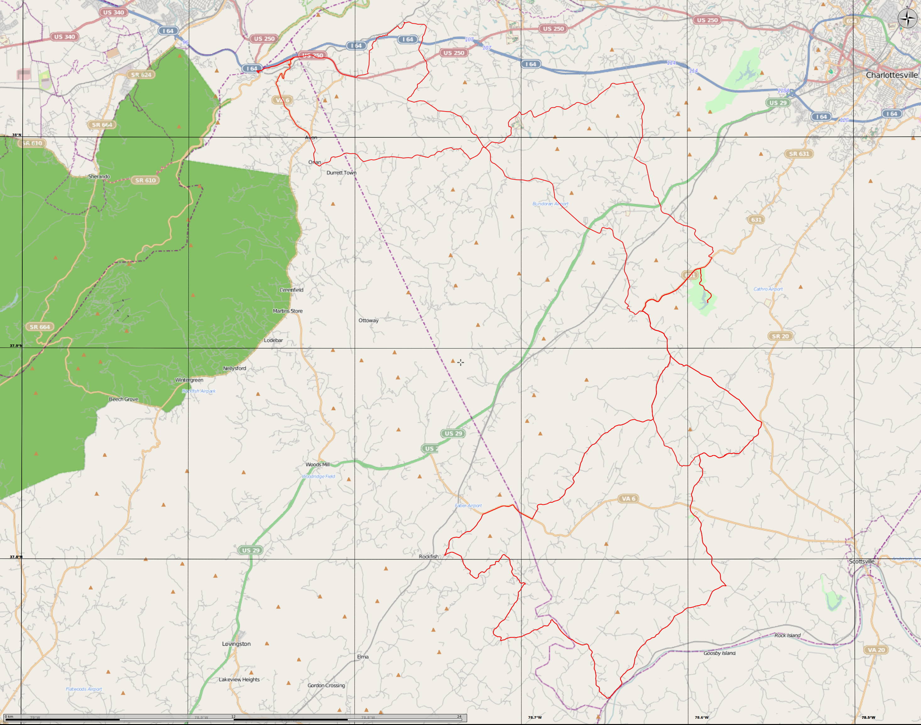
A KML file with all three routes combined is attached.
Communications plan: TBD
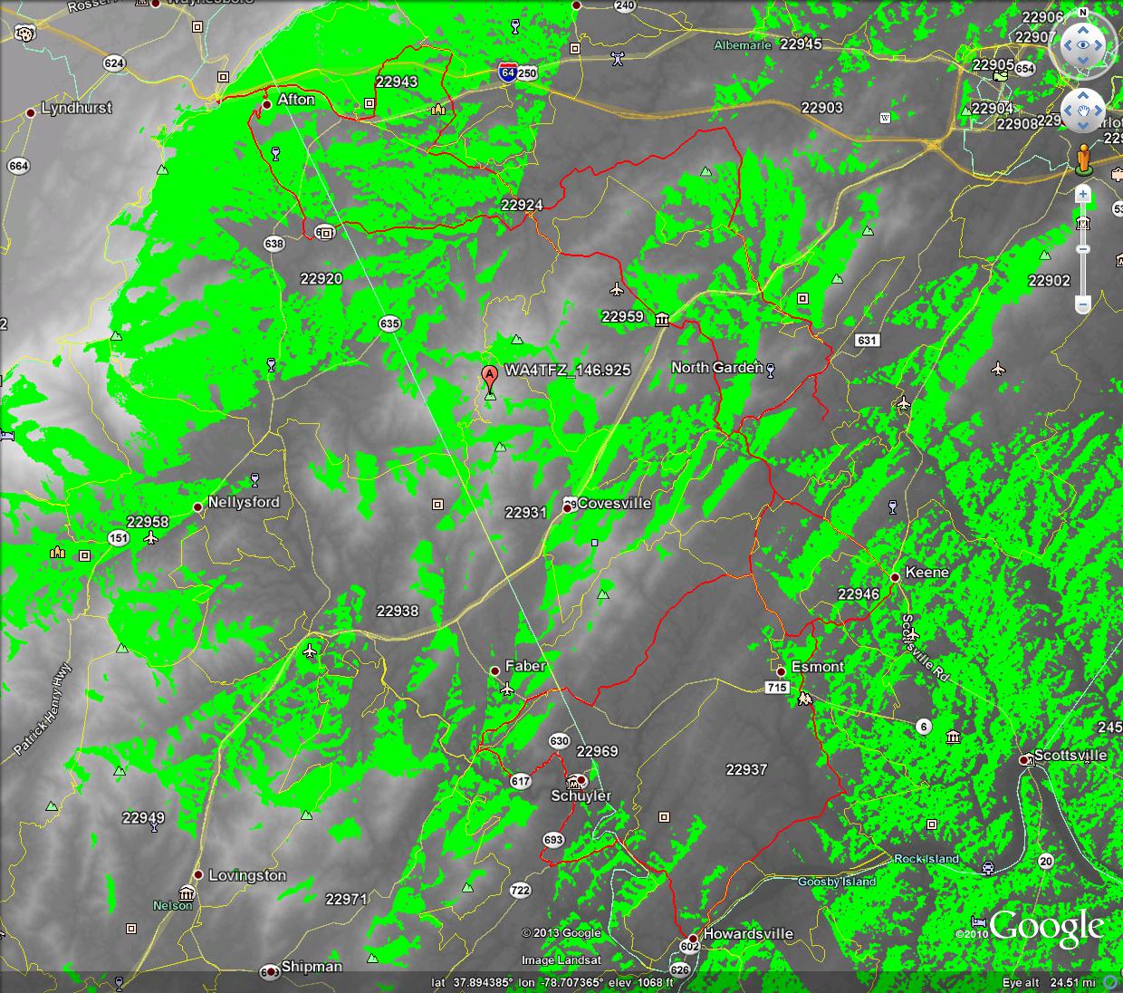
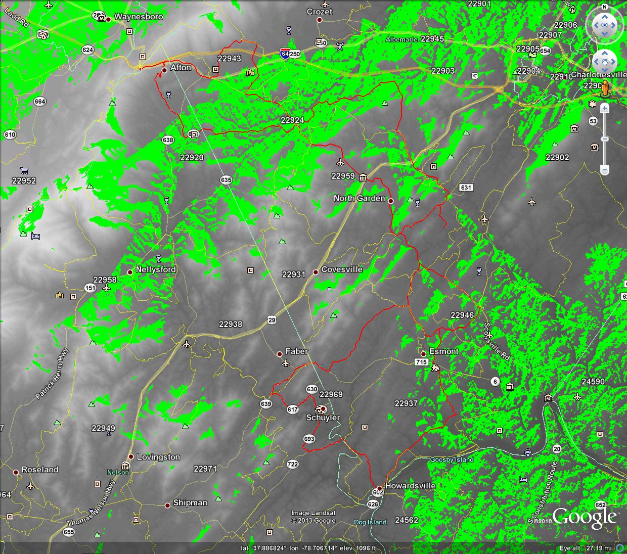
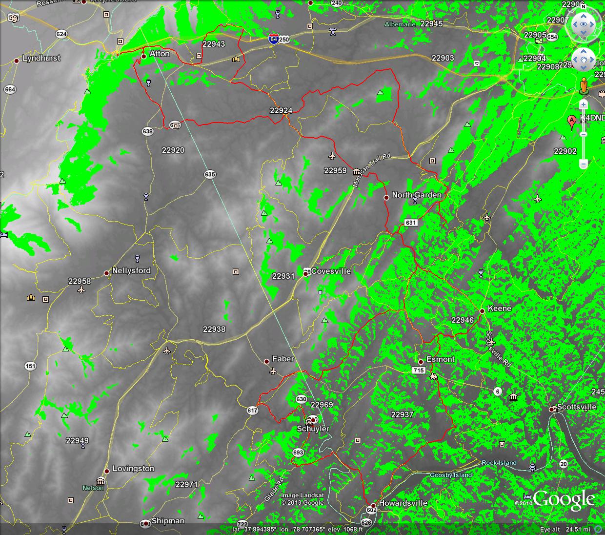
It is likely that the western loops will not be reachable by the 146.760 (currently broken) or 146.730 repeaters but will probably be reachable by the 146.895 repeater. However, the 146.895 repeater may not cover the southern route. The club 146.925 repeater is somewhat centrally located between the western and southern loops. It apears, however, that significant portions will be shaded by mountains or ridges.
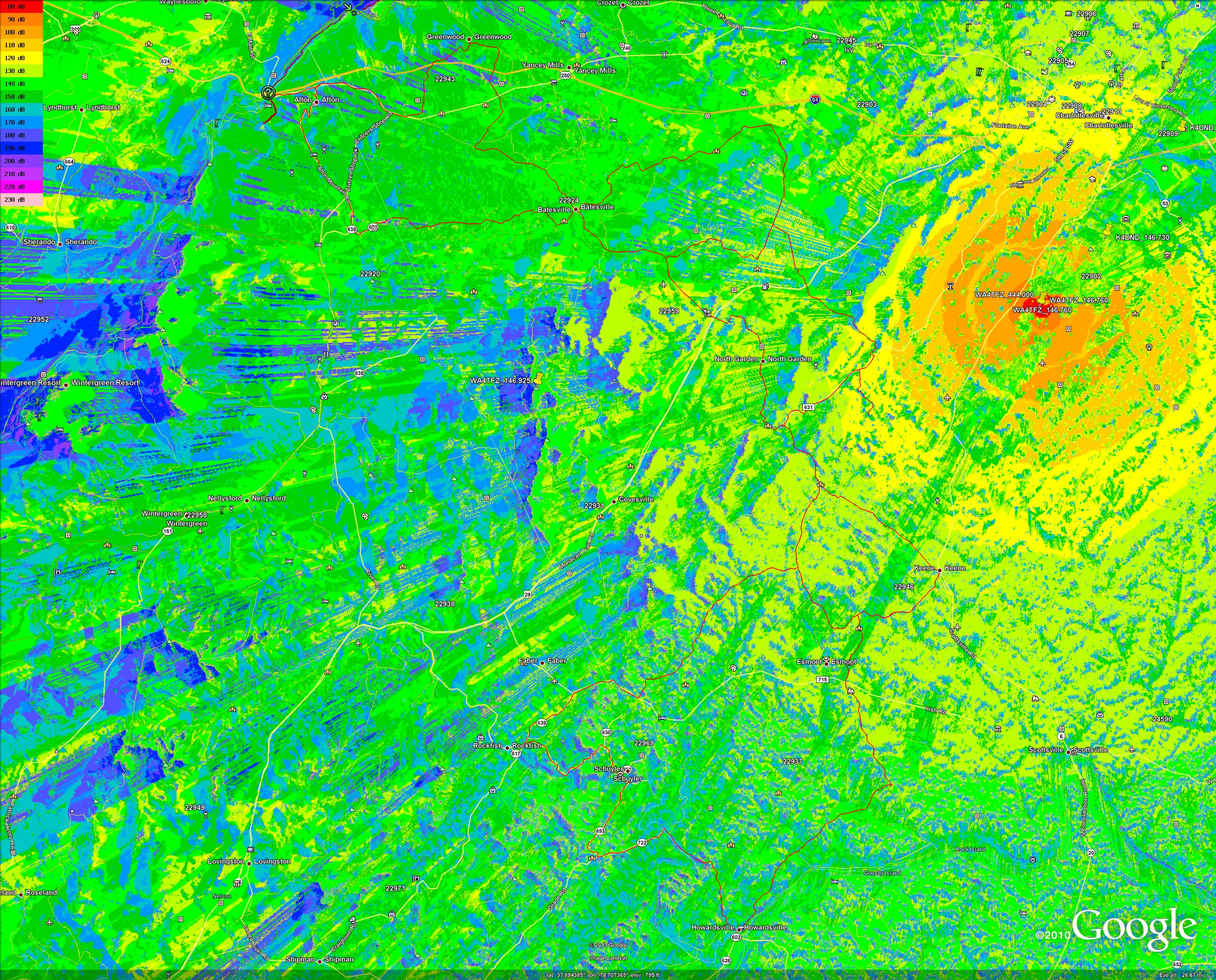
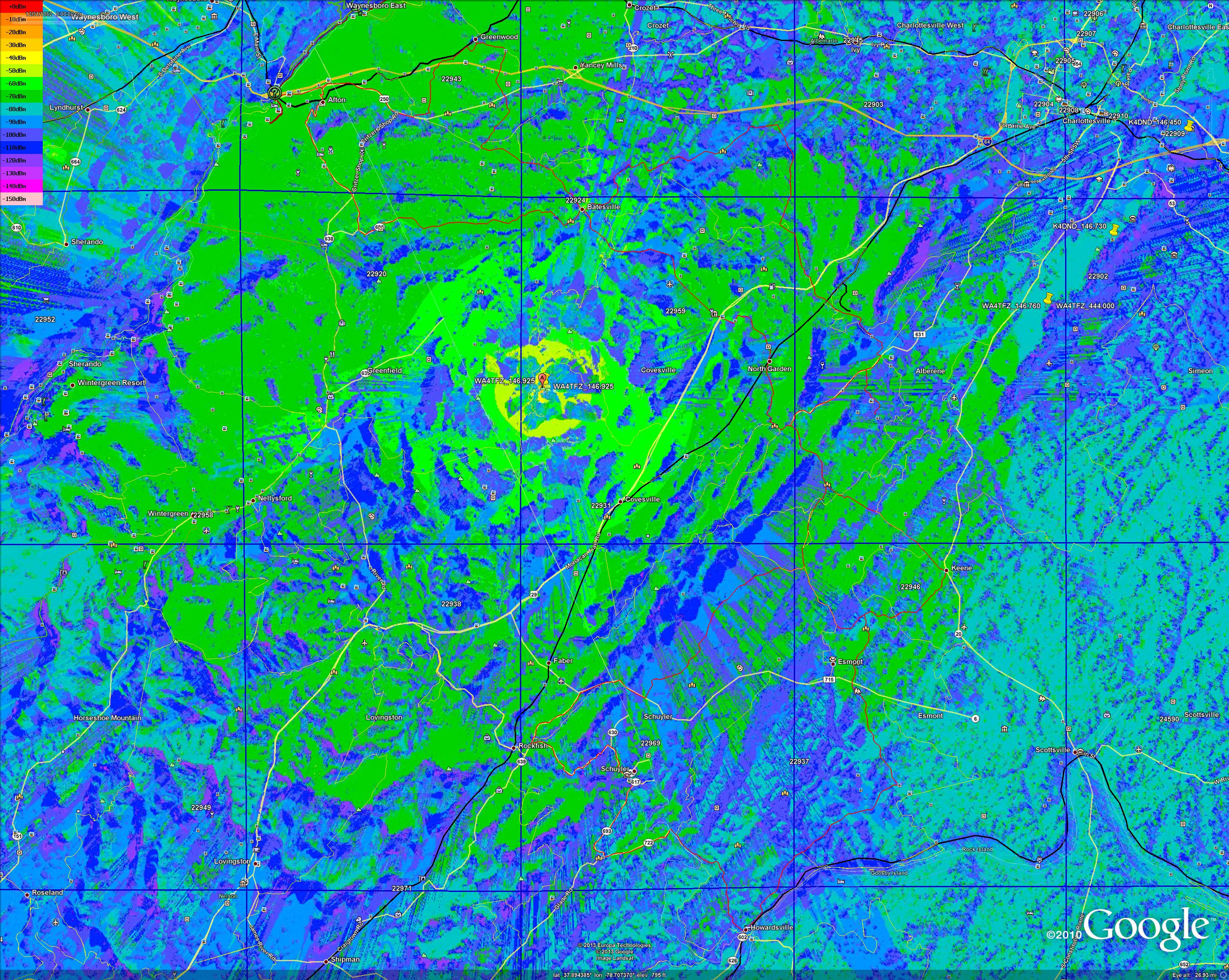
Line of Site (LOS) propagation maps generated with SPLAT! HD show line of site coverage of local repeaters. The do not include difraction or refraction effects which may fill in some of the shadows slightly on the far side but generally not the side nearest the transmitter. They do not show the detrimental or sometimes beneficial effects of trees or buildings. It looks to me like we will need 146.895, 146.925, and either 146.760 or 146.730 combined to get reasonable coverage of the route.
These images don’t link to the full size versions; to enlarge (browser dependent) try right clicking on the images and select “view image”, then click the magnifying glass to zooom in).
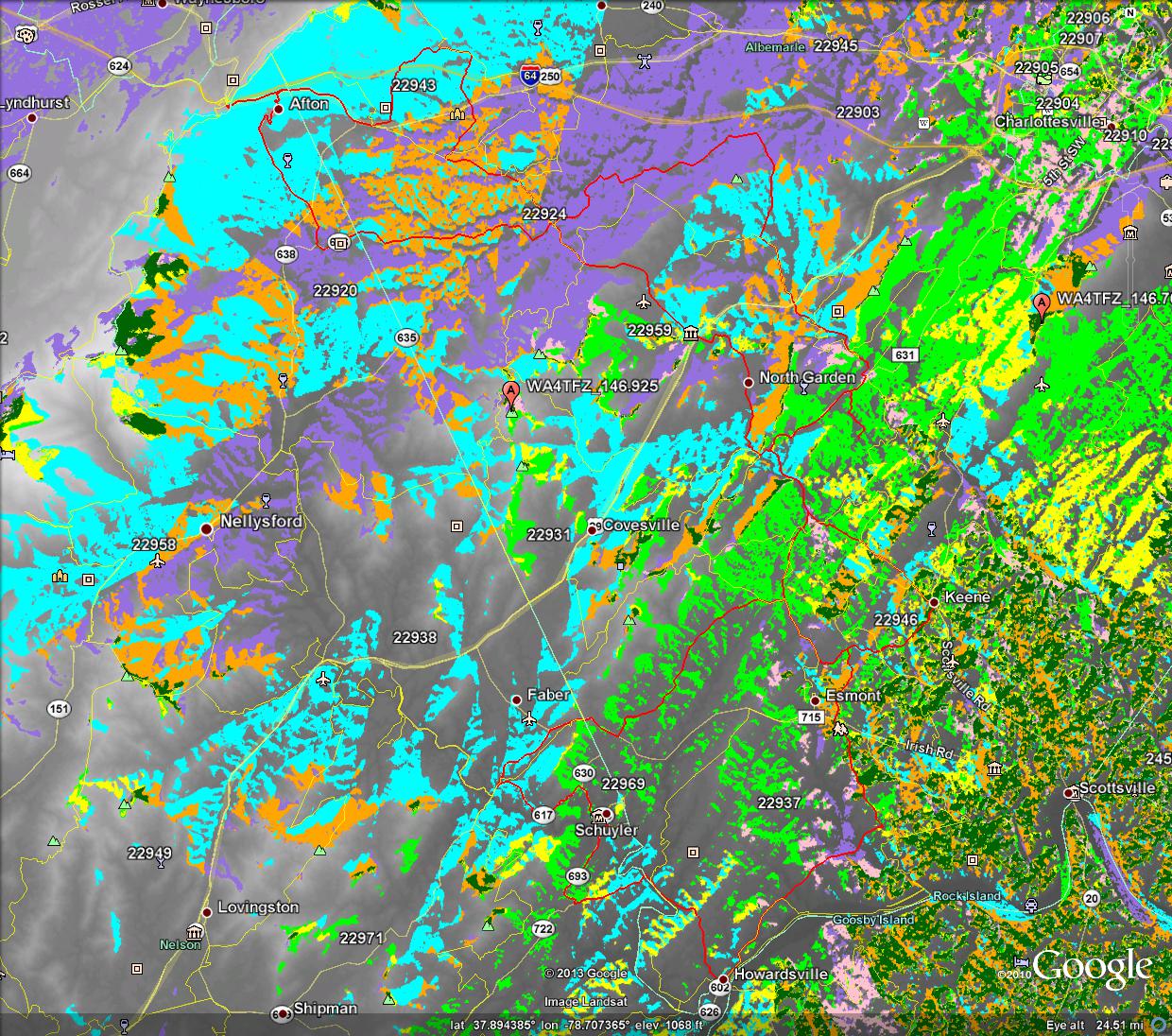
LOS Propagation Map WA4TFZ_146.925 over Gran Fondo Virginia Route:
LOS Propagation Map WA4TFZ_146.895 over Gran Fondo Virginia Route:
LOS Propagation Map WA4TFZ_146.760 over Gran Fondo Virginia Route

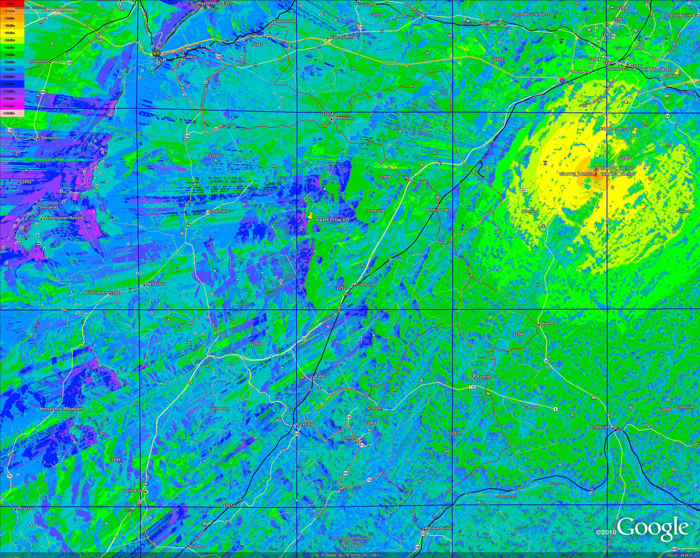
LOS Propagation Map K4DND_146.730 over Gran Fondo Virginia Route
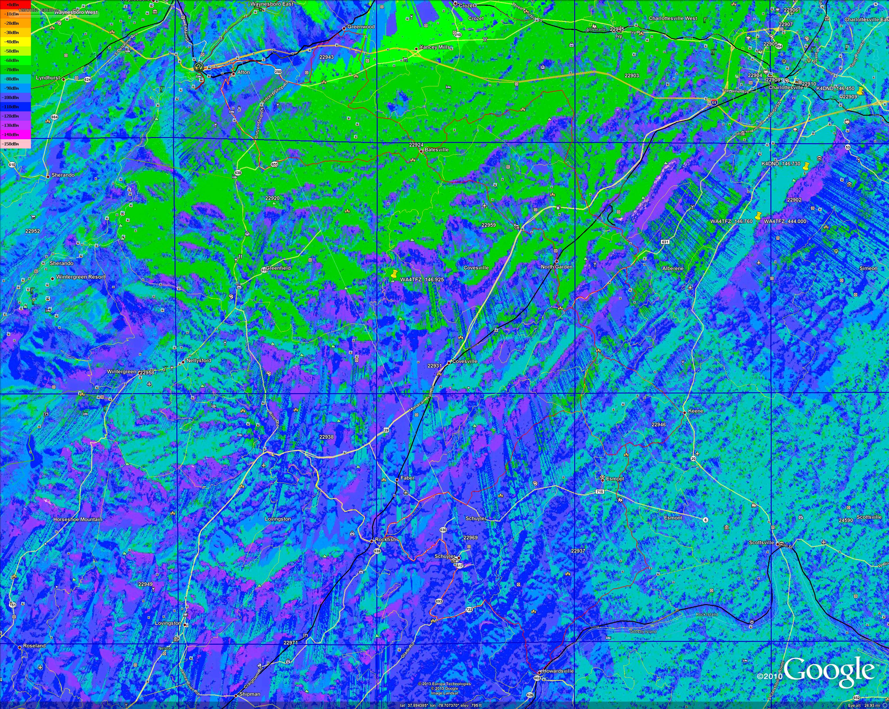
LOS Propagation Map K4DND_146.450 over Gran Fondo Virginia Route

LOS Propagation MAP Combined 146.760, 146.895, 146.925 repeaters:
Green: WA4TFZ_146.760
Cyan: WA4TFZ_146.925
Medium Violet: 146.895
Yellow: 760+925
Pink: 760+895
Orange: 925+895
Dark Green: 760+925+895
This map shows 146.760 having coverage on my street but not at my house and the other two repeaters having no coverage. Reception is indeed spotty here.
Here is a pathloss propagation map. This does take into account diffraction and propagation but doesn’t have right values for ground conductivity and dielectric constant, etc. as it was produced by accident. It isn’t quite as pessimistic as the LOS map, depending on what you consider an acceptable loss.
Note to propagation survey team: the north/west section of the 100mile version of this race includes most of the miller school loop.
Original publication: Tue, 09/03/2013 – 03:06. Date altered to sort to top of sticky list.
Update 2013-09-07: Added maps
Green, yellow, orange or red are good (-70dBm to -0dBm)
Don’t forget to enlarge the images.
Signal Strength 146.760Mhz Repeater:
Signal Strength 146.895Mhz Repeater:
Signal Strength 146.925Mhz Repeater:
Legend for 3 maps above:
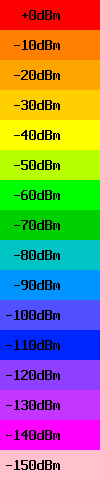 VHF S-meter levels (may be worse with poor antenna)
-93dBm S9
-99dBm S8
-105dBm S7
-111dBm S6
-117dBm S5
-123dBm S4
-129dBm S3
-135dBm S2
-141dBm S1
Note that the S-meter ratings were with a transmiitter at the repeater site that is able to get around 25watts to the antenna. Your HT wil have about 7dB less power and often more loss due to rubber duck (one rubber duck was 17dB worse than another) so transmitting back to the repeater is more iffy).
animate -resize 1436x1146 -delay 50 -pause 1 WA4TFZ_146_760_signalstrength_gran_fondo.jpg WA4TFZ_146_895_signalstrength_gran_fondo.jpg WA4TFZ_146_925_signalstrength_gran_fondo.jpg